
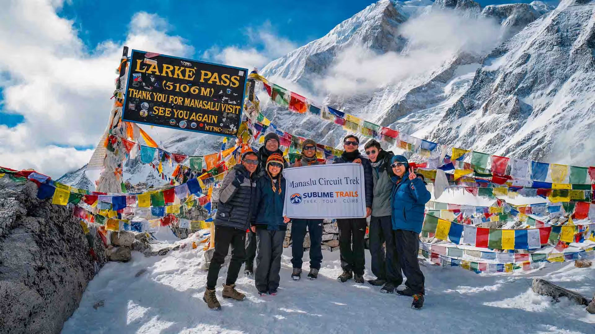
The eighth-highest mountain on earth, and a trail with a fraction of Everest's foot traffic. Thirteen days: drive to Machha Khola, walk the Budhi Gandaki gorge through Jagat, Deng, and Namrung to Samagaon, cross Larkya La Pass at 5,106m, and descend through Bimthang into the Marsyangdi valley. Two full acclimatization days, four required permits, and noticeably fewer trekkers than Nepal's two most famous circuits.
The Manaslu Circuit Trek is a 13-day restricted-area trek around the world's eighth-highest mountain, crossing Larkya La Pass at 5,106m and requiring a licensed guide by law. It sees a fraction of the trekker traffic of Everest Base Camp or the Annapurna Circuit.
Manaslu doesn't announce itself the way Everest or Annapurna do. There's no famous base camp trail worn smooth by decades of trekkers, no village that's become a small city because of the traffic passing through it. What there is instead is a 177-kilometer circuit around the world's eighth-highest mountain. Suspension bridges span gorges deep enough to lose the sound of the river below. The trail only reopened to outside trekkers in 1991, and it still caps at a fraction of Everest's visitor numbers.
What Makes the Manaslu Circuit Trek Different From Everest or Annapurna
If you've trekked in Nepal before, Everest Base Camp, the Annapurna Circuit, Manaslu will feel immediately less finished, in the best sense. Teahouses are simpler. Villages haven't been rebuilt around tourism the way Namche or Manang have. What you get in exchange is a circuit that still feels like it did when it first opened decades ago. Real solitude and genuinely unfiltered village life come with it. So does a summit-day pass, Larkya La at 5,106m, that rivals Thorong La for drama, with a fraction of the people around you when you cross it.
Who Actually Books the Manaslu Circuit Trek
Trekkers who've usually done one demanding Himalayan trek already and specifically want less company on the next one. It's also a strong fit for anyone drawn to Tibetan-influenced culture more than Sherpa culture. The upper villages here, particularly Samagaon and Samdo, sit close enough to the Tibetan border that daily life, architecture, and monastery practice all reflect it directly.
This is a fully guided, lodge-based trek around the Manaslu massif, run as a restricted-area circuit requiring a licensed guide throughout. It combines road transport at both ends with eleven days of trekking, crossing Larkya La Pass at the circuit's midpoint before descending into the Marsyangdi valley.
Trip Highlights
Journey Highlights
The Budhi Gandaki Gorge: Nepal's Most Dramatic Suspension Bridges
Some of the most striking bridge crossings in the country, spanning a river gorge deep enough to lose the sound of the water below.
Larkya La Pass (5,106m): A High Crossing With a Fraction of the Crowds
One of Nepal's great high-altitude crossings, comparable in scale to Thorong La or the approach to Everest Base Camp, reached without the visitor numbers either of those routes now carries.
Manaslu Base Camp Side Trip (4,790m): An Optional Half-Day From Samagaon
Close-up views of the world's eighth-highest peak, reachable during the Samagaon acclimatization day without adding time to the main itinerary.
Samagaon and Samdo: Tibetan Border Villages, Not Sherpa Country
: Architecture, monastery practice, and daily life here all reflect direct proximity to the Tibetan border, distinct from the Sherpa culture most trekkers associate with Nepal's mountains.
This Region Is Genuinely Less Developed
- Rockier trails, simpler teahouses, and less connectivity than Everest or Annapurna. That's central to the appeal, not a drawback.
A Guide Is Legally Required, Not Optional
- The Manaslu region has required a licensed guide from a registered agency since 2015. This applies to every trekker, solo or otherwise.
Solo Trekkers Need a Partner or a Surcharge
- The Restricted Area Permit requires a minimum of two trekkers per application. Solo travelers typically pay a premium to cover the second permit, or we can pair you with another solo trekker on request.
Road Construction Is Changing the Lower Trail
- A road toward Larke Pass and the Tibet border has already affected some lower sections between Arughat and Jagat. The upper sections above Namrung remain unaffected.
Manaslu Circuit Trek Permits and Fees, 2026
Four separate permits are required to trek the Manaslu Circuit legally. Fees vary by season for the Restricted Area Permit specifically, which is the main cost driver.
| Permit | Season | Cost (USD, per person) |
| Restricted Area Permit (RAP) | Sep to Nov, first 7 days | US$100 |
| Restricted Area Permit (RAP) | Sep to Nov, each additional day | US$15 |
| Restricted Area Permit (RAP) | Dec to Aug, first 7 days | US$75 |
| Restricted Area Permit (RAP) | Dec to Aug, each additional day | US$10 to 15 |
| Manaslu Conservation Area Permit (MCAP) | Year-round | US$25 to 30 |
| Annapurna Conservation Area Permit (ACAP) | Year-round | US$20 to 30 |
| TIMS Card | Year-round | US$10 |
A minimum of two trekkers is required to apply for the Restricted Area Permit. All four permits are arranged for you as part of this package and processed through a registered trekking agency, which is mandatory for this restricted region.
How Much Does the Manaslu Circuit Trek Cost in 2026?
A standard guided Manaslu Circuit Trek costs between US$1,200 and US$1,900 per person for a group booking, including permits, guide, porter, teahouse accommodation, and meals during the trek. Solo trekkers typically pay 30 to 50% more, given the two-person minimum on the Restricted Area Permit. Budget independent arrangements can run as low as US$950, while luxury lodge-based versions of this trek can exceed US$3,000.
How Difficult Is the Manaslu Circuit Trek?
The Manaslu Circuit Trek is rated moderately challenging to strenuous, comparable in overall difficulty to the Annapurna Circuit or Everest Base Camp Trek. The main physical demands are the 5,106m Larkya La Pass crossing and rougher, less-maintained trail conditions than Nepal's two more established circuits. Two full acclimatization days, at Samagaon and Samdo, are built in specifically to manage altitude risk ahead of the pass.
Itinerary
Manaslu Circuit Trek Detailed Itinerary
Day 1 - Drive from Kathmandu to Machha Khola
Kathmandu → Malekhu (Prithvi Highway split) → Dhading Besi → Arughat Bazar → Soti Khola → Machha Khola
Starting Destination: Kathmandu (1,400 m / 4,593 ft)
Final Destination: Machha Khola (869 m / 2,851 ft)
Sleeping Altitude: 869 m / 2,851 ft
Elevation Loss: -531 m / -1,742 ft
Driving Distance/Duration: ~160 km (99 miles) | 8 to 10 hours
Difficulty: Easy
Accommodation: Tea House
Meals: Lunch & Dinner
Overnight: Machha Khola
We leave Kathmandu early in the morning, driving west along the Prithvi Highway before turning onto rural mountain roads toward Arughat and Soti Khola. As the paved road gives way to dirt tracks winding along the lower Budhi Gandaki River, we pass terraced farmlands, small subtropical villages, and rushing river gorges. We arrive in the vibrant riverside settlement of Machha Khola by late afternoon, where we check into our teahouse and prepare our gear for tomorrow's first foot leg.
Day 2 - Trek from Machha Khola to Jagat
Machha Khola → Khorlabesi → Tatopani (Natural Hot Springs) → Dobhan → Yaru Phant → Jagat (MCAP/Restricted Area Permit Checkpoint)
Starting Destination: Machha Khola (869 m / 2,851 ft)
Final Destination: Jagat (1,340 m / 4,396 ft)
Sleeping Altitude: 1,340 m / 4,396 ft
Elevation Gain: 471 m / 1,545 ft
Walking Distance/Duration: ~22 km (13.7 miles) | 6 to 8 hours
Difficulty: Moderate
Accommodation: Tea House
Meals: Breakfast, Lunch & Dinner
Overnight: Jagat
Our foot journey begins along narrow canyon paths carved into the rock walls, following the turquoise Budhi Gandaki River upstream. We cross cantilever bridges and pass small mule caravans heading into the upper valley. Along the way, we stop at the natural hot springs of Tatopani to rest before crossing a long suspension bridge over the river. A final steady ascent brings us to the neat stone-paved village of Jagat, where we present our restricted-area trekking permits at the official park checkpost.
Day 3 - Trek from Jagat to Pewa
Jagat → Salleri → Sirdibas → Philim (Large Gurung Village) → Ekle Bhatti → Pewa
Starting Destination: Jagat (1,340 m / 4,396 ft)
Final Destination: Pewa Village (1,600 m / 5,249 ft)
Sleeping Altitude: 1,600 m / 5,249 ft
Elevation Gain: 260 m / 853 ft
Walking Distance/Duration: ~16 km (10 miles) | 5 to 6 hours
Difficulty: Moderate
Accommodation: Tea House
Meals: Breakfast, Lunch & Dinner
Overnight: Pewa
Leaving Jagat, we enter a vibrant cultural transition zone as Hindu lower-valley hamlets yield to Buddhist mountain settlements. We hike past carved mani walls and colorful prayer flags near Salleri and Sirdibas, crossing the river over a high suspension bridge at Ghatta Khola. The valley narrows significantly into a dramatic pine-scented gorge. We push past busy trail hubs to spend a peaceful evening in Pewa, a quiet riverside hamlet known for its intimate teahouse hospitality.
Day 4 - Trek from Pewa to Namrung
Pewa → Deng (1,860 m) → Rana → Bihi Phedi → Ghap (Lunch stop) → Lunga Chhyuda → Namrung
Starting Destination: Pewa (1,600 m / 5,249 ft)
Final Destination: Namrung (2,630 m / 8,628 ft)
Sleeping Altitude: 2,630 m / 8,628 ft
Elevation Gain: 1,030 m / 3,379 ft
Walking Distance/Duration: ~19.5 km (12.1 miles) | 6 to 7 hours
Difficulty: Demanding
Accommodation: Tea House
Meals: Breakfast, Lunch & Dinner
Overnight: Namrung
The trail today leads us deep into dense bamboo, oak, and rhododendron glades. Crossing the river at Deng, we enter the historic Nubri region, watching for grey langur monkeys swinging through the high tree canopy. As we gain steady elevation, the gorge opens up to reveal views of Siringi Himal (7,187 m). A series of switchbacks up a forested cliffside brings us to Namrung, a mountain village renowned for its ancient stone houses and wide barley fields.
Day 5 - Trek from Namrung to Lho
Namrung → Lihi (2,900 m) → Sho → Lho (Perched beautifully under the direct gaze of Mount Manaslu's north face)
Starting Destination: Namrung (2,630 m / 8,628 ft)
Final Destination: Lho (3,180 m / 10,433 ft)
Sleeping Altitude: 3,180 m / 10,433 ft
Elevation Gain: 550 m / 1,805 ft
Walking Distance/Duration: ~10.5 km (6.5 miles) | 4 to 5 hours
Difficulty: Moderate
Accommodation: Tea House
Meals: Breakfast, Lunch & Dinner
Overnight: Lho
We enjoy a shorter walking day packed with extraordinary high-mountain scenery. Passing through the Tibetan-influenced villages of Lihi and Sho, we observe traditional flat-roofed stone homes, chortens, and women weaving hand-spun textiles. As we climb into Lho, Mount Manaslu (8,163 m) comes into sudden, dramatic view directly above the village. We spend the afternoon exploring Ribung Gompa, watching the golden evening sunlight illuminate Manaslu’s twin summits.
Day 6 - Trek from Lho to Sama Gaun
Lho → Shyala (3,520 m, famous for 360-degree mountain panoramas) → Sama Gaun
Starting Destination: Lho (3,180 m / 10,433 ft)
Final Destination: Sama Gaun (3,530 m / 11,581 ft)
Sleeping Altitude: 3,530 m / 11,581 ft
Elevation Gain: 350 m / 1,148 ft
Walking Distance/Duration: ~17 km (10.5 miles) | 4 to 5 hours
Difficulty: Moderate
Accommodation: Tea House
Meals: Breakfast, Lunch & Dinner
Overnight: Sama Gaun
Our path ascends gently through fir and rhododendron woodlands into Shyala village, where a 360° amphitheatre of icy peaks—including Himalchuli, Peak 29, and Manaslu—frames the horizon. Continuing across alpine yak pastures, we drop into the broad valley of Sama Gaun. This large, historic Nubri settlement serves as the chief trekking hub and base camp staging point for the region. We check into our teahouse early to rest up for tomorrow's acclimatization day.
Day 7 - Acclimatization Trip to Manaslu Base Camp or Pungyen Gompa
Starting Destination: Sama Gaun (3,530 m / 11,581 ft)
Final Destination: Sama Gaun (3,530 m / 11,581 ft)
Sleeping Altitude: 3,530 m / 11,581 ft
Manaslu Base Camp Elevation: 4,800 m / 15,748 ft
Pungyen Gompa Elevation: 4,000 m / 13,123 ft
Walking Distance/Duration: ~12–14 km (7.5–8.7 miles) round trip | 6 to 8 hours
Difficulty: Strenuous / Very Hard
Accommodation: Tea House
Meals: Breakfast, Lunch & Dinner
Overnight: Sama Gaun
To help our bodies adapt to the thinning air before tackling Larkya La, we embark on an active side trip. You can choose a challenging hike up to Manaslu Base Camp (4,800 m), ascending moraine ridges to touch the edge of the Manaslu Glacier alongside international expedition teams. Alternatively, a gentler walk leads across high pastures to the sacred 400-year-old Pungyen Gompa, nestled directly beneath Manaslu’s massive east wall. We return to Sama Gaun for a warm dinner.
Day 8 - Trek from Sama Gaun to Samdo
Sama Gaun → Budhi Gandaki River wooden bridge → Larkya Bazar (abandoned Tibetan seasonal market site) → Samdo village
Starting Destination: Sama Gaun (3,530 m / 11,581 ft)
Final Destination: Samdo (3,860 m / 12,664 ft)
Sleeping Altitude: 3,860 m / 12,664 ft
Elevation Gain: 330 m / 1,083 ft
Walking Distance/Duration: ~8.5 km (5.3 miles) | 3 to 4 hours
Difficulty: Moderate
Accommodation: Tea House
Meals: Breakfast, Lunch & Dinner
Overnight: Samdo
Following the Budhi Gandaki River upward through open juniper scrub and alpine meadows, we walk past long mani walls carved with Tibetan scripts. The valley widens as we approach the Tibetan border trade routes. A short climb brings us into Samdo, a traditional yak-herding village founded by Tibetan refugees in the 1950s. Located at the strategic junction of three mountain passes, Samdo offers an authentic glimpse into high-altitude border culture.
Day 9 - Acclimatization Day in Samdo (Day Trip to Tibet Border)
Samdo Village → Ancient Salt Trade Route valley → Fukang Glacier base tracks → Rui La Pass Summit (4,998 m / 16,398 ft / Tibet Border Pillar) → Return via same path
Starting Destination: Samdo (3,860 m / 12,664 ft)
Final Destination: Samdo (3,860 m / 12,664 ft)
Sleeping Altitude: 3,860 m / 12,664 ft
Rui La Pass Elevation: 4,998 m / 16,398 ft
Walking Distance/Duration: ~16–18 km (10–11.2 miles) round trip | 6 to 8 hours
Difficulty: Strenuous / Very Hard
Accommodation: Tea House
Meals: Breakfast, Lunch & Dinner
Overnight: Samdo
We take a second deliberate acclimatization day to ensure optimal altitude safety. We hike up the valley ridge toward Rui La Pass (4,998 m), an ancient trading saddle leading directly into Tibet. Along the trail, we enjoy views of blue sheep grazing on the slopes and expansive Himalayan vistas spanning the Samdo Glacier. We descend back to Samdo by early afternoon to pack our bags and rest for the pass crossing.
Day 10 - Trek from Samdo to Dharmasala (Larke Phedi)
Samdo → Larke Bazar path split → Cross the wooden bridge over the Buri Gandaki River → Climb up the lateral moraine of the Larkya Glacier → Dharmasala
Starting Destination: Samdo (3,860 m / 12,664 ft)
Final Destination: Dharmasala (4,460 m / 14,633 ft)
Sleeping Altitude: 4,460 m / 14,633 ft
Elevation Gain: 600 m / 1,969 ft
Walking Distance/Duration: ~7–8 km (4.3–5 miles) | 3 to 5 hours
Difficulty: Demanding to Strenuous
Accommodation: Tea House / Camp
Meals: Breakfast, Lunch & Dinner
Overnight: Dharmasala (Larke Phedi)
We cross a wooden bridge over the Budhi Gandaki for the final time and begin our gradual ascent toward the base of the pass. Passing the historic ruins of the seasonal Larke Bazaar, we move across stark, windswept moraine landscapes surrounded by glaciers. We arrive at Dharmasala (Larke Phedi) by early afternoon. After a light, warm lunch and a thorough briefing on equipment for tomorrow's pass crossing, we go to bed early to prepare for a pre-dawn wake-up call.
Day 11 - Dharmasala to Bimthang via Larkya La Pass (5,106 m)
Dharmasala → Climb alongside the Larkya Glacier lateral moraine → Cho Chanda lake basin → Larkya La Pass Summit (5,106 m / 16,752 ft) → Technical scree descent → Dangboche (Larccia Kharka) → Bimthang
Starting Destination: Dharmasala (4,460 m / 14,633 ft)
Final Destination: Bimthang (3,590 m / 11,778 ft)
Sleeping Altitude: 3,590 m / 11,778 ft
Elevation Gain: 646 m / 2,120 ft
Walking Distance/Duration: ~16 km (10 miles) | 8 to 10 hours
Difficulty: Strenuous / Very Hard
Accommodation: Tea House
Meals: Breakfast, Lunch & Dinner
Overnight: Bimthang
We set off by headlamp light around 4:00 AM, climbing steadily across icy moraine ridges and lateral glacier paths. As dawn breaks, the prayer flags marking the summit of Larkya La Pass (5,106 m) come into view. From the top, we are rewarded with a panorama of Himlung Himal (7,126 m), Kang Guru, Annapurna II (7,937 m), and Cheo Himal. After photos, we make a long, careful descent down snow slopes and scree, reaching the meadows of Bimthang by late afternoon.
Day 12 - Trek from Bimthang to Dharapani
Bimthang → Habu (Crossing the Dudh Khola) → Karche (Lunch stop) → Gho → Tilije (Large, culturally rich Gurung village) → Thonje (Crossing the Marsyangdi River) → Dharapani
Starting Destination: Bimthang (3,590 m / 11,778 ft)
Final Destination: Dharapani (1,860 m / 6,102 ft)
Sleeping Altitude: 1,860 m / 6,102 ft
Elevation Loss: -1,730 m / -5,676 ft
Walking Distance/Duration: ~24 km (15 miles) | 6 to 8 hours
Difficulty: Moderate to Demanding
Accommodation: Tea House
Meals: Breakfast, Lunch & Dinner
Overnight: Dharapani
Our descent continues down through alpine pastures, past the rushing waters of the Dudh Khola. Walking into thick pine, oak, and rhododendron forests, the air grows warmer and oxygen-rich. We pass through small settlements at Sangure Karpu and Tilije—a vibrant Gurung village famous for local architecture—before crossing the Marsyangdi River suspension bridge into Dharapani, where the Manaslu Circuit joins the classic Annapurna trail.
Day 13 - Drive from Dharapani to Kathmandu via Besisahar
Dharapani → Syange → Bhulbhule → Besisahar (Exit Checkpoint) → Dumre → Mugling → Malekhu → Kathmandu
Starting Destination: Dharapani (1,860 m / 6,102 ft)
Final Destination: Kathmandu (1,400 m / 4,593 ft)
Sleeping Altitude: 1,400 m / 4,593 ft
Elevation Loss: -460 m / -1,509 ft
Driving Distance/Duration: ~195 km (121 miles) | 8 to 10 hours
Difficulty: Easy
Accommodation: Hotel
Meals: Breakfast & Lunch
Overnight: Kathmandu
We bid farewell to the mountains and board a 4x4 vehicle in Dharapani for a scenic drive along the Marsyangdi River gorge to Besisahar. Here, we transfer to a comfortable highway vehicle for the smooth return drive to Kathmandu along the Prithvi Highway. Arriving in the capital by late afternoon, we check into your hotel, giving you time to enjoy a hot shower, get a massage, and celebrate the completion of your Manaslu journey over a celebratory dinner.
Getting There
Kathmandu's Tribhuvan International Airport is served by direct and one-stop flights from most major hubs in Asia and the Gulf. Travelers from the US, Europe, and Australia typically connect through Doha, Istanbul, Delhi, Singapore, or Bangkok. Unlike Everest, this trek has no flight option to its trailhead. The journey to Machha Khola is entirely by road, roughly 7 to 8 hours by jeep or local bus from Kathmandu.
Sublime Trails representative will come to pick you at the airport. So we will be meeting at Tribhuvan International Airport to start the amazing journey.
Map And Altitude Chart
Manaslu Circuit Trek Map and Altitude Chart
Interactive Map
Cost Details
Inclusions & Exclusions
What’s Included
- All ground transport: Kathmandu to Machha Khola and Dharapani to Kathmandu
- All teahouse accommodation and meals during the trek
- Licensed guide and porter (1 porter per 2 trekkers, up to 20kg)
- All four required permits: RAP, MCAP, ACAP, and TIMS
- Comprehensive first aid kit and daily health monitoring
What’s Excluded
- Travel and rescue insurance, including high-altitude helicopter evacuation coverage (mandatory)
- Nepal visa fee
- Kathmandu hotel accommodation
- Guide and porter tips
Food and Accommodation
What You’ll Eat & Where You’ll Stay
Lower-valley teahouses offer a reasonable range: dal bhat, noodle soups, momos, basic Western options. Menus narrow significantly above Samagaon, where supply logistics are more limited than on Everest or Annapurna. Expect simpler, more repetitive meals at Samdo and Dharamsala specifically.
Equipment list
Manaslu Circuit Trek Equipment list

Know before you go! Some stuff we’ll provide, other things you’ll need to bring.
Reviews
Client’ Testimonials and their Experiences
S
Excellent experience
We went on Manaslu Circuit trek, with guide Prakash and porters Kamal and Ram. It was a very challenging and tiring circuit, with long days back to back.
Two of us fell sick, and Prakash arranged for Kamal to stay with them while the others went on a day hike. Kamal was attentive and made sure that the sick were well rested and recovering.
We were also very lucky to catch an annual sporting festival at Samagaun! Prakash also made last minute changes to best suit our fitness and pace of hike.
The guides and porters also went the extra mile to help us find village food such as yak jerky and sea buckthorn juice.
Highly recommended guides and porters!
G
Excellent trekking service
We embarked on the Manasgu Circuit trek with our amazing guide, Prakash, and porters, Kamal and Ram. The journey was incredibly challenging, with long, consecutive trekking days, but also immensely rewarding.
Our guide and porters went above and beyond to enhance our experience, helping us discover local village delicacies like yak jerky and refreshing sea buckthorn juice. I bought so many local products on the mountains and the porters did not even complain. Their dedication and support made the trek even more memorable.
When I was limping, Prakash helped to find a sturdy and light bamboo stick which carried me throughout the trip. He also had cream to help with the pain. The porters also brought a lot of fruits to offer us every dinner from Kathmandu for the whole trip.
We also saw many other interesting things that is not part of the trip like the bees on the cliff side for mad honey, sea buckthorn tree, and Binendra Lake from another angle.
We highly recommend Prakash, Kamal, and Ram to anyone looking for an unforgettable adventure in the Himalayas!
R
A memorable experience
Had a great time hiking the Manaslu circuit trek.
The weather during our trip was not ideal so the conditions were challenging but our guide, Ajit, had us feel super safe and comfortable at all times. Ajit made sure we had accommodation even with last-minute changes to the itinerary due to the weather. Will definitely use sublime again when I come back!
Essential
Know Everything Before You Go Manaslu Circuit Trek
Currency & ATMs
Exchange currency in Kathmandu before departure, since this itinerary starts and ends there entirely by road. ATMs don't exist beyond Machha Khola, so carry sufficient cash for the full thirteen days. Budget roughly US$200 to 250 in cash for personal spending along this remote route.
Travel Insurance
Travel insurance is not legally required to enter Nepal or obtain a visa. It is required by us before you can start this trek, the same as every itinerary we run.
Your policy needs high-altitude coverage to at least 6,000m and helicopter evacuation coverage, given Larkya La Pass at 5,106m. Confirm your policy covers evacuation from this specific region, since Manaslu sees far less flight traffic than Everest or Annapurna, and some policies define coverage zones narrowly.
Buy your policy before you leave home. Evacuation here takes longer to arrange than on our Everest or Annapurna products, given this region's more limited helicopter access.
Nepal Visa
Most nationalities, including US, UK, EU, Australian, and Canadian citizens, can get a Nepal visa on arrival at Tribhuvan International Airport. You can also apply online in advance. A 15 day visa is tight for this thirteen day itinerary. Choose 30 days for genuine buffer around weather or permit delays. Indian citizens don't need a visa at all.
Travel Etiquette
- Always pass mani walls, chortens, and prayer wheels on your left, walking clockwise. This is a real Buddhist observance, not a suggestion, particularly in Samagaon and Samdo's Tibetan influenced villages.
- Ask before photographing monks, ceremonies, or people directly. A smile and a gesture toward your camera is usually enough. A shaken head means no, and that's the end of it.
- Remove your shoes before entering Pungyen Gompa or any monastery prayer hall. Keep your voice low inside.
- Yield the trail to porters, yaks, and mule trains. Stay on the uphill side when you do.
- A donation at any monastery along the route is appreciated but never expected. Don't make a show of it either way.
- Samagaon and Samdo reflect direct Tibetan border influence, distinct from Sherpa or Gurung culture elsewhere in Nepal. Approach both with genuine curiosity, not assumptions from other treks.
- Tipping is customary, not mandatory, and matters more than it might seem. Guides and porters rely on it as real income. Ask your operator for a typical range rather than guessing.
Training for the Manaslu Circuit Trek
This trek reaches 5,106m at Larkya La Pass, genuinely comparable in demand to our Annapurna Circuit or Everest Base Camp products. Train accordingly, starting at least 12 weeks out.
- Cardio, 3 to 4 times a week, building toward 90 minute sessions. Thirteen days with one major pass crossing asks for sustained fitness, not just a single peak effort.
- Load-bearing hikes with a daypack at 6 to 8kg, at least once weekly in your final month. This region's rougher, less maintained trail conditions demand more from your footing than our Everest or Annapurna routes.
- Prior high altitude experience is genuinely useful. This trek's two acclimatization days at Samagaon and Samdo make it a reasonable second major trek for well prepared trekkers.
- Fitness doesn't prevent altitude sickness. Larkya La demands the same respect as any 5,100m crossing in Nepal, with less support infrastructure if problems arise.
Porter and Weight Limitation
Each porter carries up to 20kg, shared between two trekkers, given this itinerary's thirteen day length. Keep your personal duffel to around 12 to 13kg for comfortable sharing. There's no flight baggage limit to plan around, since this entire route is reached by road.
Electricity & Connectivity
Electricity and charging are available at most teahouses. Costs increase progressively above Namrung given this region's more limited supply chain. A power bank is essential from Samagaon onward. Mobile data through NTC or Ncell is patchy above Samagaon and largely absent near the pass.
Kathmandu to Machha Khola Road Conditions
This trek uses road transport only, with no domestic flight option at any point. Manaslu has no trailhead airstrip the way Everest does.
The Kathmandu to Machha Khola drive runs roughly 7 to 8 hours. It is rougher and less developed than our Langtang or Annapurna region transfers. Expect a genuinely long, winding journey rather than a quick highway drive.
Road construction toward Larke Pass is actively changing the character of the lower trail sections between Arughat and Jagat. This itinerary continues to evolve as more of the route becomes road accessible.