
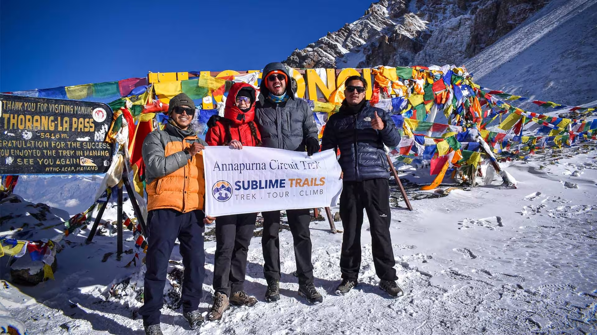
The same legendary pass, reached in ten days by avoiding the sections a new road has changed. A longer initial drive to Chame or Koto, then newer trail alignments above the Marsyangdi road through Pisang and into Manang, a genuine acclimatization day, and the crossing of Thorong La Pass into Muktinath, all in ten days rather than fourteen. The modern way to do the classic circuit.
A road now runs through a meaningful stretch of the lower Marsyangdi valley, the same ground the classic Annapurna Circuit itinerary was built to walk. Newer trail alignments have been cut above and around much of that road specifically so trekkers can avoid sharing the path with jeeps and motorbikes, and this itinerary uses them deliberately, combined with a longer initial drive, to reach Thorong La Pass in ten days instead of fourteen.
This Is a Genuinely Different Route, Not a Faster Copy
It matters that this page and our 14 day Annapurna Circuit pillar are not the same product wearing two names. The pillar starts walking from Chamje and takes the full traditional pace through every stage of the Marsyangdi valley. This itinerary drives further before the walking starts, specifically to skip the sections most affected by the new road, and uses the newer, higher trail alignments on the sections where a genuine walking path still exists apart from the vehicle track. The destination, Thorong La Pass, is identical. The days it takes to get there, and the trail surface underfoot for a meaningful share of the route, are not.
Who This Is Actually For
Trekkers who want Thorong La Pass and the Manang to Muktinath experience without a 14 day time commitment, and who have specifically read about road construction affecting the lower Marsyangdi valley and want a route built around minimizing that. It suits returning Nepal trekkers more than complete first timers, since the compressed schedule asks for solid fitness from day one.
This is a fully guided, lodge based trek crossing Thorong La Pass using a longer initial drive and newer trail alignments that avoid much of the motorable road now present in the lower Marsyangdi valley, completing the same core circuit as our 14 day pillar in ten days.
Trip Highlights
Journey Highlights
Thorong La Pass
5,416m, the same crossing our full 14 day pillar route makes, reached in four fewer days
Newer trail
A route built specifically around current trail conditions, not a decades old itinerary applied unchanged. Newer trail alignments above the Marsyangdi road, a genuinely different walking surface and experience from the classic lower valley stage
Acclimatization day at Manang
Manang's high desert terrain and its acclimatization day, kept fully intact despite the compressed schedule
Muktinath
One of Nepal's most significant pilgrimage sites for both Hindus and Buddhists
This is not a lesser version of the Annapurna Circuit. It reaches the identical pass using a longer drive and different, newer trail sections, and it removes the multi day walk through the lower Marsyangdi valley that our full pillar itinerary still includes. If that lower valley experience, including Dharapani and Chame reached on foot, matters to you as much as the pass itself, our 14 Day Classic route is the better fit.
A Different Route, Not a Rebrand
- This itinerary genuinely uses newer trail sections above the road, not just a faster version of our 14-Day Classic.
The Same Pass, Four Fewer Days
- Thorong La is identical either way. What changes is the lower valley approach, driven instead of walked.
One Rest Day Stays Non-Negotiable
- Compressing the schedule doesn't touch Manang's acclimatization day. That stays exactly where it belongs.
Built for Returning Trekkers More Than First-Timers
- If Ghorepani and Poon Hill's sunrise matter to you as much as the pass, our 14-Day Classic is the better fit.
Itinerary
Annapurna Circuit Trek 10 Days, Modern Route Detailed Itinerary
Day 1 - Drive from Kathmandu to Chamje
Kathmandu → Mugling → Besisahar (Permit Checkpoint) → Syange → Chamje
Starting Destination: Kathmandu (1,400 m / 4,593 ft)
Final Destination: Chamje (1,410 m / 4,626 ft)
Sleeping Altitude: 1,410 m / 4,626 ft
Elevation Gain: 10 m / 33 ft
Driving Distance/Duration: ~215 km (133.5 miles) total distance | 8 to 10 hours total drive time
Difficulty: Easy
Accommodation: Tea House
Meals: Lunch & Dinner
Overnight: Chamje
Leaving Kathmandu at 6:00 AM lets us beat the morning traffic. The highway start is smooth, but the real test begins at Besisahar. There, we switch to a 4x4 jeep for a bumpy, four-hour dirt road cut into steep cliffs. Sit on the left side of the jeep for the best views of the river canyon. If you get motion sickness, avoid a heavy lunch and pack ginger candies. We reach Chamje by late afternoon, just in time for a hot cup of ginger tea to wash away the road dust.
Day 2 - Drive from Chamje to Chame
Chamje → Tal → Karte → Dharapani → Bagarchhap → Danaque → Timang → Koto → Chame
Starting Destination: Chamje (1,410 m / 4,626 ft)
Final Destination: Chame (2,670 m / 8,759 ft)
Sleeping Altitude: 2,670 m / 8,759 ft
Elevation Gain: 1,260 m / 4,133 ft
Driving Distance/Duration: ~32 km (20 miles) | 3 to 4 hours
Transportation: 4x4 Jeep
Accommodation: Tea House
Meals: Breakfast, Lunch & Dinner
Difficulty: Easy
Overnight: Chame
Today also, we skip the dusty lower walking trail entirely. We take the jeep higher up the valley to save your knees and help your body adjust to the thin air. Keep your passport and permits at the top of your pack for the Dharapani checkpoint. You will feel the air get cold quickly as the green bamboo changes to thick pine forests. In Chame, drop your bags and cross the bridge to the local hot springs. Soak your feet to relax your muscles, but do not sit all the way in the hot water if you feel dizzy from the high altitude.
Day 3 - Trek from Chame to Lower Pisang
Chame → Bhratang (Famous Apple Farm) → Paungda Danda Viewpoint (The Great Ice Wall) → Dhukur Pokhari → Lower Pisang
Starting Destination: Chame (2,670 m / 8,759 ft)
Final Destination: Lower Pisang (3,200 m / 10,499 ft)
Sleeping Altitude: 3,200 m / 10,499 ft
Elevation Gain: 530 m / 1,740 ft
Walking Distance/Duration: ~15 km (9.3 miles) | 5 to 6 hours
Difficulty: Moderate
Accommodation: Tea House
Meals: Breakfast, Lunch & Dinner
Overnight: Lower Pisang
Our actual walking journey begins today. We head west through thick, sweet-smelling pine forests along the river on a full-day hike. Make sure your boots are tied tight so your toes do not hit the front of the rocky path. Look to your right to see Swarga Dwari, a giant rock wall that rises straight up into the sky. After crossing a high bridge, the air changes from humid to a crisp, dry mountain breeze. We reach Lower Pisang by early afternoon. Change out of your sweaty shirt right away so you do not catch a cold when the strong 2:00 PM valley winds start blowing.
Day 4 - Trek from Lower Pisang to Manang Valley
Lower Pisang → Humde (Airport & Checkpoint) → Bhraga (Ancient Monastery) → Manang Village
Starting Destination: Lower Pisang (3,200 m / 10,499 ft)
Final Destination: Manang Valley (3,540 m / 11,614 ft)
Sleeping Altitude: 3,540 m / 11,614 ft
Elevation Gain: 340 m / 1,115 ft
Walking Distance/Duration: ~16 km (10 miles) | 4 to 5 hours
Difficulty: Moderate
Accommodation: Tea House
Meals: Breakfast, Lunch & Dinner
Overnight: Manang Valley (Manang Village)
Moving on from Pisang, we follow the flat lower valley road to save your energy for the big pass ahead. We walk past a small mountain airstrip and long stone walls carved with prayers. Local custom says you must always walk past these prayer walls on the right side. The snowy mountain peaks look close enough to touch. As we get near the old village of Braga, look up at the cliffs to see a 500-year-old monastery built into the rock. The thin air will make your legs feel heavy now, so slow down to a steady crawl as we enter Manang.
Day 5 - Acclimatization Day in Manang
Manang Village → Gangapurna Lake / Chongkor Viewpoint (or optional Ice Lake/Praken Gompa) → Return to Manang Village
Starting Destination: Manang Valley (3,540 m / 11,614 ft)
Final Destination: Manang Valley (3,540 m / 11,614 ft)
Sleeping Altitude: 3,540 m / 11,614 ft
Elevation Gain: 0 m / 0 ft
Walking Distance/Duration: Flexible | Typically 2 to 3 hours (~4–6 km)
Difficulty: Easy to Strenuous
Accommodation: Tea HouseMeals: Breakfast, Lunch & Dinner
Overnight: Manang Valley
Today, we do not just stay in bed. To help your body get used to the thin air, we follow the mountain rule: climb high, sleep low. In the morning, we take a very slow walk up to a viewpoint above the bright green Gangapurna Lake, then come back down for lunch. At 3:00 PM, we go to the local clinic for a quick, helpful talk by volunteer doctors on mountain safety. Afterward, walk down the old stone alleys to the Tilicho Bakery. You can grab a hot slice of apple pie and use their Wi-Fi to send a message to family back home.
Day 6 - Trek from Manang to Yak Kharka
Manang Village → Tengi Manang → Gunsang (Panoramic view of Annapurna massifs) → Yak Kharka
Starting Destination: Manang Valley (3,540 m / 11,614 ft)
Final Destination: Yak Kharka (4,020 m / 13,189 ft)
Sleeping Altitude: 4,020 m / 13,189 ft
Elevation Gain: 480 m / 1,575 ft net gain
Walking Distance/Duration: ~10.5 km (6.5 miles) | 3.5 to 4.5 hours
Difficulty: Moderate to Demanding
Accommodation: Tea House
Meals: Breakfast, Lunch & Dinner
Overnight: Yak Kharka
We leave the main valley behind and head north. The green trees stop completely, replaced by low shrubs and open grass. Every step takes more work now that we are above 4,000 meters, so keep your steps small and steady. You will see grazing yaks along the trail. Do not get close to them, and always stay on the inside mountainside of the path if they walk past you. We cross a small wooden bridge and reach Yak Kharka. Sit by the warm dining room stove, drink hot garlic soup to help your blood flow, and sleep early.
Day 7 - Trek from Yak Kharka to Thorong Phedi
Yak Kharka → Ledar (4,200 m) → Deurali Tea House (Crossing the Jhong Khola suspension bridge) → Landslide Zone → Thorong Phedi
Starting Destination: Yak Kharka (4,020 m / 13,189 ft)
Final Destination: Thorong Phedi (4,450 m / 14,599 ft)
Sleeping Altitude: 4,450 m / 14,599 ft
Elevation Gain: 430 m / 1,410 ft net gain
Walking Distance/Duration: ~7.5 km (4.6 miles) | 3 to 4 hours
Difficulty: Demanding
Accommodation: Tea House
Meals: Breakfast, Lunch & Dinner
Overnight: Thorong Phedi
This is a short walk, but it is hard on your lungs as we get close to the bottom of the pass. The path goes along high slopes before crossing a bridge over the river. Next, we enter a landslide zone where loose rocks can drop from above. Keep your eyes up, listen for clicking sounds, and walk quickly without stopping until you are safe. We reach Thorong Phedi (Foot of the Pass) by lunch. Once there, we spend the afternoon resting, hydrating, and organizing our cold-weather gear for tomorrow's big climb.
Day 8 - Conquer Thorong La Pass (5,416 m) & Trek to Muktinath
Thorong Phedi → High Camp (4,880 m) → Thorong La Pass Summit (5,416 m / 17,769 ft) → Charabu (Chabarbu) → Muktinath (Ranipauwa)
Starting Destination: Thorong Phedi (4,450 m / 14,599 ft)
Final Destination: Muktinath (3,760 m / 12,335 ft)
Sleeping Altitude: 3,760 m / 12,335 ft
Elevation Loss: -1,656 m / -5,433 ft
Walking Distance/Duration: ~14 km (8.6 miles) | 7 to 9 hours
Difficulty: Strenuous / Very Hard
Accommodation: Tea House
Meals: Breakfast, Lunch & Dinner
Overnight: Muktinath
We wake up at 3:30 AM in the freezing dark. The first climb up to High Camp is a very steep zig-zag path that will test your energy. From High Camp, move like a slow turtle because you will need three big breaths for every single step. Use your walking poles on the icy spots. When you finally see the colorful prayer flags at the top of Thorong La Pass (5,416 m), the feeling is amazing. After celebrating our achievement at the pass, we begin a long descent of over 1,600 meters into the arid landscapes of Lower Mustang, reaching the sacred pilgrimage site of Muktinath by late afternoon.
Day 9 - Drive from Muktinath to Pokhara via Kali Gandaki Gorge
Muktinath → Kagbeni → Jomsom → Marpha (Famous Apple Village) → Ghasa → Tatopani (Hot Springs) → Beni → Baglung Highway → Pokhara
Starting Destination: Muktinath (3,760 m / 12,335 ft)
Final Destination: Pokhara (822 m / 2,697 ft)
Sleeping Altitude: 822 m / 2,697 ft
Elevation Gain: -2,938 m / -9,638 ft
Driving Distance/Duration: ~175 km (108 miles) | 7 to 9 hours
Difficulty: Easy
Accommodation: 3-Star Hotel
Meals: Breakfast, Lunch & Dinner
Overnight: Pokhara
Today we transition back to a private jeep—the journey descends through the Kali Gandaki Valley, passing traditional villages like Jomsom and Marpha via the world's deepest river gorge between Dhaulagiri and Annapurna I. On the way, we pause near Tatopani for lunch before leaving the rain-shadow desert and dropping into warm, green hills. By evening, we check into our Lakeside hotel in Pokhara for a hot shower and a relaxing evening beside Phewa Lake.
Day 10 - Drive from Pokhara to Kathmandu
Pokhara → Damauli → Dumre → Mugling → Malekhu → Galchi → Thankot Checkpoint → Kathmandu
Starting Destination: Pokhara (822 m / 2,697 ft)
Final Destination: Kathmandu (1,400 m / 4,593 ft)
Sleeping Altitude: 1,400 m / 4,593 ft
Elevation Gain: 578 m / 1,896 ft
Driving Distance/Duration: ~200 km (124 miles) | 6 to 8 hours
Difficulty: Easy
Accommodation: 3-Star Hotel
Meals: Breakfast & Lunch
Overnight: Kathmandu
After breakfast in Pokhara, we board our jeep back to Kathmandu. The road winds along the Trishuli and Marsyangdi rivers, offering views of rural terraced farms, cable cars over the river, and bustling roadside towns like Mugling. Upon reaching Kathmandu by late afternoon, you can relax at your hotel or shop for souvenirs in Thamel. In the evening, Sublime Trails hosts a farewell dinner featuring authentic Nepali cuisine and traditional live cultural performances to celebrate your journey.
Getting There
Kathmandu's Tribhuvan International Airport is served by direct and one stop flights from most major hubs in Asia and the Gulf. Travelers from the US, Europe, and Australia typically connect through Doha, Istanbul, Delhi, Singapore, or Bangkok. From Kathmandu, this trek continues by road to Chamje, with the return route using a short domestic flight from Jomsom to Pokhara before the final drive back to the capital.
Sublime Trails representative will come to pick you at the airport. So we will be meeting at Tribhuvan International Airport to start the amazing journey.
Map And Altitude Chart
Annapurna Circuit Trek 10 Days, Modern Route Map and Altitude Chart
Interactive Map
Cost Details
Inclusions & Exclusions
What’s Included
- All ground transport, including the longer Kathmandu to Koto drive and the Jomsom to Pokhara flight
- 3 star hotel in Kathmandu, 2 nights, and 3 star hotel in Pokhara, 1 night
- All teahouse accommodation and meals during the trek
- Licensed guide and porter (1 porter per 2 trekkers, up to 20kg)
- ACAP and TIMS permits
What’s Excluded
- Travel and rescue insurance, including helicopter evacuation coverage (mandatory)
- Nepal visa fee
- Personal expenses: Wi-Fi, hot showers, battery charging, bottled water, alcohol
- Guide and porter tips
Food and Accommodation
What You’ll Eat & Where You’ll Stay
Meals shift character across the trek: the lower Marsyangdi valley offers dal bhat, noodle soups, and momos with genuine variety, while Manang and the high desert stretch toward Thorong Phedi narrow to simpler, higher calorie options as supply lines lengthen. Marpha, on the descent side, is a specific highlight, its apple orchards support small bakeries and distilleries, and apple pie or apple brandy here is a real, distinctive stop rather than a generic trail snack. Expect roughly US$4 to 6 for a main meal in the lower villages, US$8 to 12 near Thorong Phedi and Manang given transport costs. Boiled or filtered water is available throughout; bottled water is discouraged for cost and plastic waste.
Equipment list
Annapurna Circuit Trek 10 Days, Modern Route Equipment list

Know before you go! Some stuff we’ll provide, other things you’ll need to bring.
Moments
Hear It From Our Travelers

We Literally Had To Do Nothing, Because Prakash, Our Guide, Was So Amazing.

I Choose To Do Another Trek with Sublime Trails
Sublime Trails is a Very Serious Company
Essential
Know Everything Before You Go Annapurna Circuit Trek 10 Days, Modern Route
Currency & ATMs
Exchange currency in Kathmandu before departure, since this itinerary starts and ends there, not in Pokhara. ATMs exist in Manang and again in Pokhara on your return leg, though card fees run 3 to 8 percent. Carry the local currency equivalent of at least US$280 in cash for the full ten days.
Travel Insurance
Travel insurance is not legally required to enter Nepal or obtain a visa. It is required by us before you can start this trek, the same as every itinerary we run.
Your policy needs high-altitude coverage to at least 6,000m and helicopter evacuation coverage, given Thorong La Pass at 5,416m, identical to our 14 day classic route. This modern itinerary reaches the same altitude with four fewer days. Confirm your coverage handles a same day evacuation rather than just a delayed rebooking. US-based trekkers commonly use UnitedHealthcare Global. European trekkers use Allianz or Europe Assist. Australian trekkers use Cover-More.
Buy your policy before you leave home. Confirm it names both the extended Koto drive and the Jomsom to Pokhara return flight under trip interruption coverage.
Nepal Visa
Most nationalities, including US, UK, EU, Australian, and Canadian citizens, can get a Nepal visa on arrival at Tribhuvan International Airport. You can also apply online in advance to save time at immigration. A 15 day visa comfortably covers this ten day itinerary with room for delays. Indian citizens don't need a visa at all.
Travel Etiquette
- Always pass mani walls, chortens, and prayer wheels on your left, walking clockwise. This is a real Buddhist observance, not a suggestion, particularly in Manang and Mustang's Tibetan influenced villages.
- Ask before photographing monks, ceremonies, or people directly. A smile and a gesture toward your camera is usually enough. A shaken head means no, and that's the end of it.
- Remove your shoes before entering a monastery prayer hall. Keep your voice low inside, especially at Muktinath.
- Yield the trail to porters, yaks, and mule trains. Stay on the uphill side when you do.
- A donation at Muktinath or any monastery along the route is appreciated but never expected. Don't make a show of it either way.
- This modern route uses newer trail sections above the motorable road in the lower valley. Where your path runs alongside the road, be mindful of vehicle traffic and local drivers going about daily business.
- Tipping is customary, not mandatory, and matters more than it might seem. Guides and porters rely on it as real income. Ask your operator for a typical range rather than guessing.
Training for the Annapurna Circuit Trek 10 Days
This itinerary reaches the identical 5,416m as our 14 day classic route, compressed into ten days rather than fourteen. Train for the destination, not the shorter number.
- Cardio, 3 to 4 times a week, building toward 90 minute sessions, the same standard as our full length route. The altitude demands don't shrink just because the itinerary does.
- Load-bearing hikes with a daypack at 6 to 8kg, at least once weekly in your final month. The one Manang rest day here does real work, and arriving fit means you use it for genuine recovery.
- Prior high altitude experience is genuinely useful, more so than on our 14 day route, since this compressed schedule leaves less room to adjust if you're struggling.
- Fitness doesn't prevent altitude sickness, and Thorong La Pass demands the same respect here as on our full length itinerary. The shorter drive to the trailhead doesn't change what happens above 4,000m.
Porter and Weight Limitation
Each porter carries up to 20kg, shared between two trekkers, the same standard as our 14 day classic route. Keep your personal duffel to around 12 to 13kg for comfortable sharing. Given the pass day's demands, keep your daypack focused on essentials. Don't over rely on quick access to porter carried gear.
Electricity & Connectivity
Electricity and charging are available at most teahouses along this route, the same as our full length itinerary. A power bank is worth carrying for the pass crossing day specifically. Mobile data through NTC or Ncell works reliably through Manang, with coverage dropping around Thorong Phedi and the pass itself.
Jomsom to Pokhara Flight Delays
This itinerary uses a domestic flight from Jomsom to Pokhara on the return leg, the same as our 14 day classic route. Jomsom sits in a narrow valley known for strong afternoon winds. Flights depart early morning specifically to avoid this pattern.
This itinerary already runs four days shorter than our classic route. A weather delay here has less schedule buffer to absorb than on the longer version. If your flight is delayed, we hold you in Jomsom for the next available window. We do not force an unsafe flight.
Build a genuine buffer day into your international return flight regardless of this itinerary's shorter overall length. The compressed schedule is exactly why this matters more here, not less.


