How to Read the Manaslu Circuit Trek Map
A trekking map isn't just about knowing where one village sits relative to another. For Manaslu, you also need to understand how the elevation changes between those points.The first part of the trek follows the Budhi Gandaki Valley through warmer and greener surroundings.
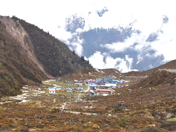
As you move towards Namrung and Lho, the valley becomes more mountainous. The landscape changes again around Sama Gaun and Samdo. Finally, the trail reaches the high, exposed terrain around Dharmasala and Larkya La.
After the pass, the route changes character once more. You descend towards Bhimtang before continuing towards Tilije. That gradual change is one of the main reasons we recommend studying the route before starting the trek. You won't just be walking from one place to another. You'll be moving through several different mountain environments.
Where Does the Manaslu Circuit Trek Start?
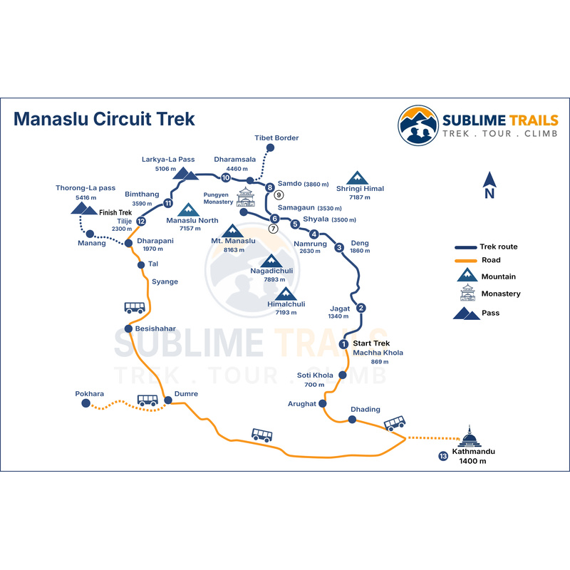
For our current itinerary, the journey begins in Kathmandu with a road transfer towards the lower Manaslu region. The trekking section starts at Machha Khola, subject to road and local conditions. From there, the trail follows the Budhi Gandaki River and gradually gains elevation.
The road journey and trekking route should be treated separately when looking at the map. Kathmandu is the trip's starting point, but Machha Khola is where the main walking journey begins.
That distinction is useful when comparing different Manaslu itineraries because some operators may use different roadheads depending on road conditions and their planned schedule.
Where Does the Manaslu Circuit Trek Finish?
The exact finishing point depends on the itinerary. On the Sublime Trails route, the trekking section continues beyond Larkya La to Bhimtang and Tilije. A road transfer then takes you towards Kathmandu or your onward destination.
This means the route shouldn't be viewed as a perfect circle on a map. It's better understood as a circuit through the Manaslu region followed by a road journey out of the mountains.
Manaslu Circuit Trek Elevation Profile
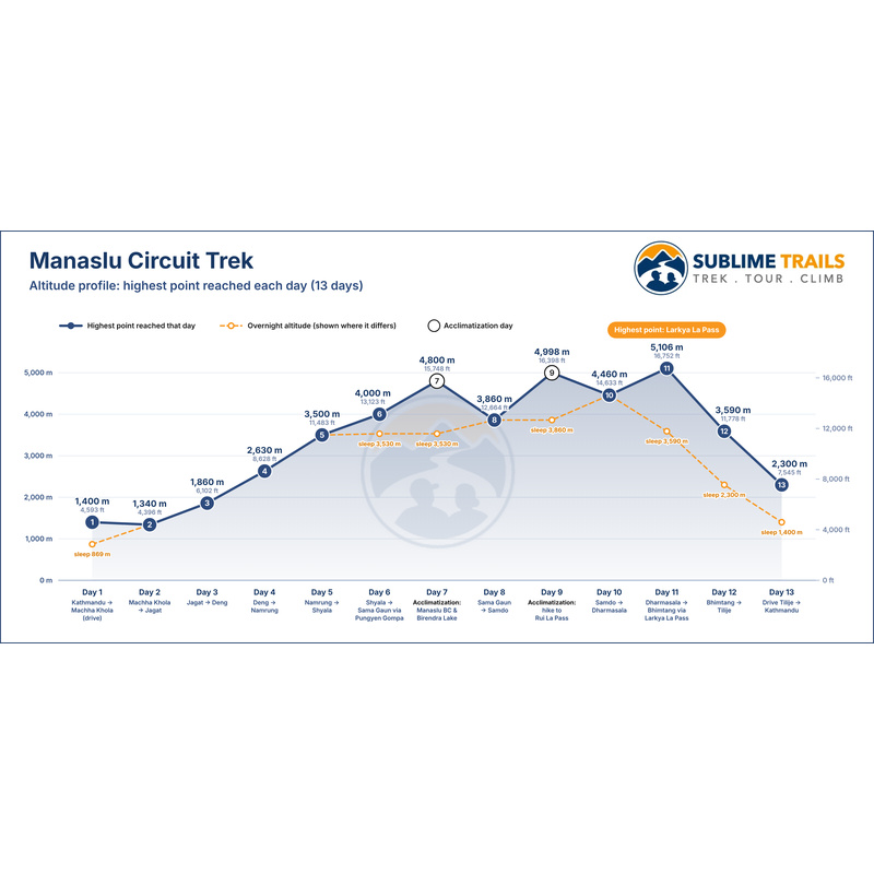
Elevation is one of the most important things to understand before starting the Manaslu Circuit. The route doesn't climb at one constant rate. Instead, it rises gradually, includes acclimatization periods and then reaches its highest point near the end.
A simplified elevation progression looks like this:
Machha Khola → Jagat → Deng → Namrung → Lho → Shyala → Sama Gaun → Samdo → Dharmasala → Larkya La → Bhimtang → Tilije
| Route Point |
Approx. Elevation |
Role on the Trek |
| Machha Khola |
869 m |
Trek starting point |
| Jagat |
1,340 m |
Lower valley checkpoint |
| Deng |
1,860 m |
Transition towards higher terrain |
| Namrung |
2,630 m |
Entry into the upper Manaslu landscape |
| Lho |
3,180 m |
First major Manaslu viewpoint |
| Shyala |
3,500 m |
High mountain settlement |
| Sama Gaun |
3,530 m |
Major acclimatization area |
| Samdo |
3,860 m |
High-altitude village |
| Dharmasala |
4,460 m |
Final overnight stop before the pass |
| Larkya La |
5,106 m |
Highest point of the route |
| Bhimtang |
3,590 m |
Major descent after the pass |
| Tilije |
Lower elevation |
Final trekking section |
These elevations follow the route used in the current Sublime Trails itinerary and are useful for understanding the overall progression rather than treating them as exact surveying data.
Why Larkya La Is the Key Point on the Map
Larkya La is the highest point of our route. On the current Sublime Trails itinerary, the pass is approximately 5,106 metres. However, the important part isn't simply the number.
You need to understand where that number appears in the itinerary. By the time you reach Larkya La, you've already spent several days gradually gaining altitude.
You've also had acclimatization opportunities around Sama Gaun and Samdo. That progression is why the route needs to be viewed as a complete journey rather than as a collection of isolated locations.
For a closer look at the pass, including its location, elevation, walking route and what to expect on crossing day, read our detailed guide to Larkya La Pass. It will help you understand what lies ahead before reaching the highest point of the Manaslu Circuit.
Major Villages and Landmarks on the Map
The route is easier to understand when you associate each village with a particular stage of the journey.
Jagat
Jagat belongs to the lower section of the Manaslu route. The surrounding landscape is still relatively green, and the trail follows the Budhi Gandaki through steep valleys. It's an early indication that the trek will gradually move into more remote mountain terrain.
Deng
Deng represents a transition towards the upper Manaslu region. The elevation is higher, the valley becomes more enclosed and the mountain environment starts to change. From here, you're steadily moving towards Namrung and the higher villages.
Namrung
Namrung is one of the key points on the route. It sits at approximately 2,630 metres on our itinerary. The trail from here leads into a landscape where the mountains become increasingly dominant.
Lho
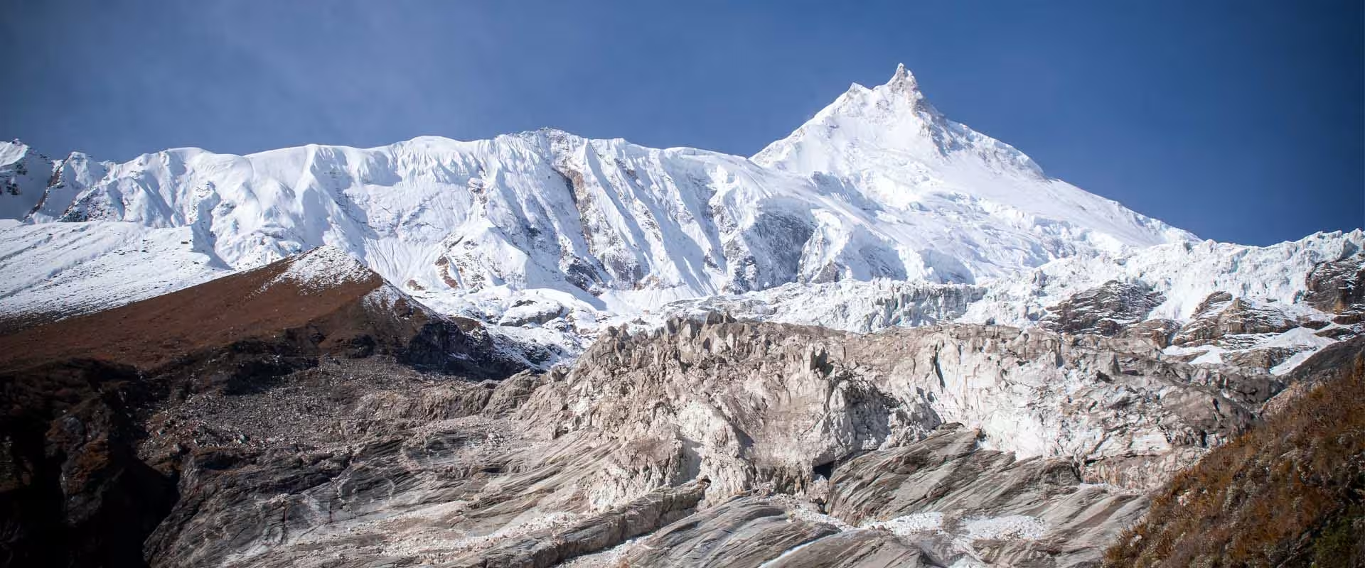
Lho is one of the memorable viewpoints on the route. From here, Mount Manaslu becomes a major presence in the landscape. The village also provides an introduction to the cultural character of the upper Manaslu region.
Shyala
Shyala is used as an overnight stop on our current itinerary. Its open mountain setting makes it a useful point to appreciate the change from the narrower lower valley to the wider alpine environment.
Sama Gaun
Sama Gaun is one of the most important locations on the map. It's where we allow time for acclimatization and exploration before pushing towards higher elevations.
Our itinerary also includes a side trip towards Pungyen Gompa and a separate acclimatization day towards Birendra Lake and Manaslu Base Camp.
Samdo
Samdo is another major high-altitude settlement. It sits close to the route's northern frontier and provides another opportunity to adjust before the final approach to the pass. Our itinerary also includes a Rui La acclimatization hike from Samdo.
Dharmasala
Dharmasala is the final overnight point before Larkya La. Once you leave this settlement, the route enters the most demanding high-altitude section of the circuit.
Bhimtang
Bhimtang village sits on the other side of Larkya La. Reaching it means you've completed the major pass crossing and begun the long descent. For many trekkers, arriving at Bhimtang feels like a major turning point in the journey.
Manaslu Circuit Trek Permits on the Route
The map also matters because part of the Manaslu route passes through a restricted trekking area. This isn't something we leave trekkers to figure out after arriving in the mountains.
Permit arrangements are completed before the trek. The Department of Immigration also publishes the rules and fees applicable to restricted trekking areas, including the Manaslu region.
For current permit requirements and fees, check our guide to Manaslu Circuit Trek permit and fees.
What to Look for on a Manaslu Circuit Trek Map
If you're comparing different maps before booking, don't just look for the longest or shortest route.
Check whether the map clearly shows:
1. Trek Starting Point
Confirm where the road journey ends and where walking begins.
2. Major Overnight Villages
Look for places such as Namrung, Sama Gaun, Samdo and Dharmasala.
3. Elevation
A route without elevation information tells only half the story.
4. Larkya La
Make sure the highest point is clearly marked.
5. Side Trips
Some itineraries include additional hikes that don't appear on a simplified circuit line.
6. Final Trekking Point
Check whether the route finishes around Bhimtang, Tilije or another location.
7. Road Sections
A road transfer can change the practical length of a trekking itinerary.
These details help you compare itineraries properly.
Conclusion
The Manaslu Circuit Trek Map is most useful when you understand what happens between the marked points.
The journey starts in the lower Budhi Gandaki Valley. The trail then climbs gradually through Jagat, Deng, Namrung, Lho and Shyala before reaching Sama Gaun. From there, the route moves higher towards Samdo and Dharmasala.
The biggest elevation change comes when you cross Larkya La. After reaching the high point, the trail descends towards Bhimtang and continues towards Tilije. That's the basic structure of the Manaslu Circuit. But the map alone doesn't tell the whole story.
The sleeping elevations, acclimatization days, side trips, weather and trail conditions all influence how the journey actually feels. That's why we use the map as a planning tool rather than treating it as a fixed line on paper.
If you're ready to plan the full journey, visit our Manaslu Circuit Trek package for the detailed itinerary, permits, costs, preparation and booking information.
Planning your Manaslu Circuit Trek? Get in touch with our team to discuss your preferred dates, itinerary and trekking requirements.